Know your warnings
Please check our know your warnings page for more information about warning levels.
Know Your Incidents
An incident is the initial occurrence of an event before it becomes a warning. As soon as an incident is reported, TasALERT publishes information including the type and location of incident. Some incidents will have more information than others.
A warning will be issued containing further information if the community are required to take action.
Other Incident
Reported location of an incident. This incident is not a fire, aircraft, rescue or hazardous materials.

Fire or Bushfire
The reported location of a fire. This may be a bushfire, grassfire, building fire, fire alarm or non-building fire. The location of the icon shows where the fire has started but does not show how far it has spread.

Planned Burn
The general location of a planned burn that is currently underway. Firefighters are managing the burn but flames and smoke may be visible.
Note: In most cases, the location of the icon shows the starting point of the planned burn.

Weather
The general location of a Severe Weather Warning, Severe Thunderstorm Warning or Coastal Hazard Warning issued by the Bureau of Meteorology.

Aircraft Accident
The reported location of an accident or incident involving a plane, helicopter or other aircraft.

Rescue
The reported location of a person trapped as a result of an industrial or recreational accident, trench or structure collapse, or a similar incident.
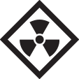
Hazardous Materials
The reported location of a spill or leak of a hazardous liquid, gas or solid. This could include chemical, radiological, biological materials, a petrol or oil spill, a ruptured gas main or an industrial lead.
Note: In most cases, the location of the icon depicts where the hazardous material is reported to be located and may not show how far it has spread.
Map Icons
Evacuation Centre
Location of an evacuation centre. Provides people with a safe shelter option away from immediate or potential effects of an emergency.
Place of Last Resort
Location of a place of last resort (Nearby Safer Place) for people to shelter during bushfire emergencies.

Cluster Icon
There are multiple warnings or incidents in this location and you will need to select the icon or zoom in to display them all.

Warning Area
The coloured area shows the predicted warning area at the time of issue. Under the Australian Warning System, the warning colour can be yellow (Advice), orange (Watch & Act), or red (Emergency Warning).
A blue coloured area shows for warnings that are not part of the Australian Warning System.
Road Closures
Location of road closures caused by emergencies or significant incidents. Note: not all road issues are reported on this site. Further information may be available from Tasmania Police – Statewide Road Closures.

Red line: No access

Green line: Local residents only

Blue line: 4WDs only
School Closures
Location of school closures caused by emergencies or significant incidents.
Government schools
Catholic schools
Independent schools
Child/family centres
Libraries